National Explosives, Gwinear-Gwithian - 1463206 | Historic England
Submitted by via Historic England on Wed, 24/07/2019 - 00:00.
National Explosives
Overview
- Heritage Category:
- Scheduled Monument
- List Entry Number:
- 1463206
- Date first listed:
- 05-Jun-2019
- Location Description:
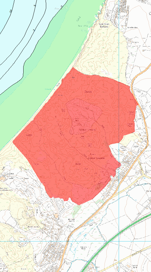
- Within the sand dunes at Upton Towans, bordered to the south-west by St Ives Bay Chalet and Caravan Park, to the north-east by Gwithian Towans, by Loggans Road to the south-east, and St Ives Bay to the north-west. NGR centred: SW5770140051.
Map
© British Crown and SeaZone Solutions Limited 2019. All rights reserved. Licence number 102006.006.
Use of this data is subject to Terms and Conditions.
The above map is for quick reference purposes only and may not be to scale. For a copy of the full scale map, please see the attached PDF - 1463206 .pdf
The PDF will be generated from our live systems and may take a few minutes to download depending on how busy our servers are. We apologise for this delay.
This copy shows the entry on 25-Jul-2019 at 17:57:51.
Location
The building or site itself may lie within the boundary of more than one authority.
- Location Description:
- Within the sand dunes at Upton Towans, bordered to the south-west by St Ives Bay Chalet and Caravan Park, to the north-east by Gwithian Towans, by Loggans Road to the south-east, and St Ives Bay to the north-west. NGR centred: SW5770140051.
- District:
- Cornwall (Unitary Authority)
- Parish:
- Gwinear-Gwithian
- District:
- Cornwall (Unitary Authority)
- Parish:
- Hayle
- National Grid Reference:
- SW5755740070
Summary
Former explosives factory begun in 1887 for the National Explosives Company, with alterations and additions until its closure in 1920.
Reasons for Designation
The former National Explosives factory at Upton
Towans, Hayle, which opened in 1889, is scheduled for the following
principal reasons:
* Period: National Explosives characterises
an uncommon example of an explosives factory built in the late C19 on a
new site but utilising its natural components, originally built to
supply the mining industry, but later as a supplier to the Royal Navy in
the First World War;
* Rarity: the factory was designed on
Continental methods under the direction of the Hungarian engineer, Oscar
Guttmann, and it may be the only example of his planning nationally
where all the component forms of the process can be read. The 1890s mass
concrete magazines are thought to be the only surviving group of their
date and type nationally;
* Survival: despite some losses, the
extensive archaeological remains provide an illustration of the layout
and organisation of the site on Continental methods, including packaging
and distribution and the factory’s growth to provide Cordite MD for the
Royal Navy in the First World War, and this contributes significantly
to our understanding of the scale and nature of explosives manufacture
in the late C19 and early C20;
* Documentation: the site is well
documented in a number of archaeological reports and publications on
the explosives industry, and historic photographs survive of the factory
in use, including of the people who worked there.
History
The National Explosives Company was an offshoot
of the Cornish Kennall Vale Gunpowder Company established near
Ponsanooth in 1811, which reached its peak in 1875 but gradually
declined with the introduction of nitroglycerine-based high explosives.
Dynamite became the most effective explosive to be used in mining and
quarrying, the sole supplier being Nobel; they held the manufacturer’s
patent until 1881 when the Privy Council dismissed their application for
its renewal, allowing production by other companies. In 1887 Kennall
managed to raise sufficient funds to set up a dynamite factory called
National Explosives, and employed Oscar Guttmann to choose a site,
design its layout and employ and train its first staff. Guttmann
(1855-1910) was a Hungarian industrial chemist and consulting engineer,
who worked at many explosives factories on the continent (including
Nobel) before moving to Britain in 1883, where he became naturalised in
1894. National Explosives was his first major commission in the country
when he accepted a position as consultant and director.
A site
in the dunes at Upton Towans north of Hayle was chosen for the National
Explosives factory in 1887. The nearby expanding market in mining and
quarrying and the potential for dynamite to replace gunpowder; access to
engineering skills in the foundries of Hayle; and proximity to a
shipping port and the national railway network were reasons for locating
it here. Additionally, since the components of dynamite (nitroglycerine
and guncotton) are volatile and highly explosive, the sandy dunes of
Upton Towans – away from the populated area but close enough to attract a
workforce – provided natural screening to confine the effects of an
accident. The natural landscape was also found to be efficiently
adaptable for the factory’s safety requirements.
The
construction of the factory began in 1889 after two years of planning;
the first batch of dynamite was produced in December that year. The
construction of the buildings was undertaken by James Julian of Truro,
and the machinery provided by Holman Brothers of Camborne. The factory
comprised two main sections. The ‘danger’ area within the dunes was
divided using a Continental approach into a ‘wet’ area for making and
storing nitroglycerine, and a ‘dry’ area where the material was
processed into marketable explosives. The topography of the dunes was
used for the falling levels of the nitroglycerine factory, resulting in
the main manufacturing area being at the highest points in the dunes,
named Jack Straw’s Hill. Workers in the danger area had to pass through
special changing and search rooms to ensure they were wearing the
correct clothing and carried no prohibited articles which could be
dangerous with explosives. A services area at the south-east of the site
comprised steam boilers, a steam-driven air compressor, electric
generators and extensive laboratories, workshops and stores. Substantial
houses were also built for management employees along Loggans Road. The
factory was managed by JW Wilkinson, with William ‘Billy’ Bate
appointed as chemist-in-charge and manager of the danger area. Separate
foremen were chosen and trained by Guttmann for the wet and dry sides of
the danger area. Staff training and human relations were carefully
attended to, and the factory became well-known for its pleasant working
conditions from the start. Initially the factory employed 175 people and
by the end of 1890 was producing three tonnes of dynamite daily.
The
factory was the most up-to-date possible, with Guttmann selecting the
most recent and efficient Continental method for making dynamite. A
first-class nitric acid factory comprising eleven cast-iron retorts set
in brick coal-fired furnaces was built to Guttmann’s specifications to
produce the volatile form required. Sodium nitrate was tipped into a
store house, from where it was mixed with sulphuric acid and heated to
form nitric acid before collection through a condensing process in
earthenware pots. From here a mixture of nitric and sulphuric acids were
blown by compressed air up a pipe to a storage hut in the wet area at
the summit of Jack Straw’s Hill. The nitroglycerine was made by
combining glycerine and the mixed acids in a nitrator, a lead vessel
packed with coils carrying cold water for cooling and pipes for
compressed air for stirring, enclosed in a wooden container. The mixture
of waste acid and nitroglycerine was run into a separator located in a
separate hut through open timber gutters on timber trestles, where after
a period of precipitation the acids were drawn off by gravity from the
nitroglycerine. This was an improvement on previous methods where the
nitroglycerine was skimmed off by hand. After washing and filtering in a
further hut, the nitroglycerine was held in stores at the foot of the
hill before being transported in rubber buckets to a mixing house, where
it was hand-mixed with kieselghur (a form of diatomaceous earth),
prepared from raw in the service area. It was then moved to the
cartridging huts where it was extruded using hand-operated cartridging
machines by three or four women in each hut to produce sticks of
dynamite, wrapped in parchmentised paper and packed into wooden crates.
The
buildings in the danger area were small and well spread-out amongst the
dunes. Massive embankments (traverses) were built from the sand to
screen the timber buildings from each other and to direct the force of
any explosion upwards, rather than outwards. The large volume of water
required by the factory was pumped from a shaft at the former Boiling
Well Mine at the south-west of the service area. The buildings were
heated by steam carried in lagged pipes on overhead trestles to ensure
that the nitroglycerine did not freeze. Extensive planting of marram
grass was undertaken to stop sand blowing off the dunes. By late 1890
the factory was fully operational, with dynamite being sold through the
Kennall gunpowder agencies, including export outside of Cornwall, and as
far as Australia.
In 1891 the factory was extended for the
manufacture of gelatinous nitroglycerine explosives. This included a new
factory in the non-danger area for nitrating cotton to make collodion.
Cotton waste was imported from Lancashire, nitrated in a mixture of
acids, and pushed into earthenware pots made by Doulton & Co. The
cotton was spun to remove the excess acid, immersed in water, and taken
to a boiling house where it was digested with several changes of
steam-heated water. In a pulping house it was chopped up into slurry,
spun and bagged and taken to a drying house. Once the cotton was dry it
was taken to the mixing houses in the danger area where it was combined
with nitroglycerine and an absorbing powder comprising potassium nitrate
and woodmeal. This produced one of the standard gelagnites used in
Britain in the 1890s.
In 1894 National Explosives embarked on a
venture to build a cordite plant, a new gun propellant made from a
mixture of guncotton, nitroglycerine, acetone and vaseline. The
expansion of the factory included a larger guncotton plant with drying
stoves, cordite mixing houses and press ranges. The Government’s plant
at Waltham Abbey had only just also started production and was not
deemed to be able to produce the amount required by the Royal Forces.
New equipment was needed to make the full range of sizes of cordite for
the Government, and the factory fell under strict regulations. In the
late C19 National Explosives was manufacturing MK1 cordite and became
its leading manufacturer as contracts rolled in. 200 people were
employed at National Explosives at this point, but it was soon to
expand. In October 1901 National Explosives - by now a company in its
own right - adopted cordite MD, which was smokeless and had less
nitroglycerine and more acetone. This expansion in cordite production
also resulted in the construction of a new nitroglycerine factory to the
west of Jack Straw’s Hill in 1905; this became known as New Nitro Hill.
Influenced by an explosion in a wash house on Jack Straw’s Hill a year
earlier, it was laid out on ‘clean lines’, comprising one nitrating
house, one separating house and two storage houses for washing,
filtering and precipitation. New cartridge huts were built at the
eastern base of the hill and a new guncotton section built to the east
of the nitric acid factory. National Explosives reached its maximum
capacity for the manufacture of blasting explosives in 1907, when it was
producing around 1000 tonnes a year of cordite, plus 2000 tonnes of
other explosives.
During the First World War Cordite MD was
insisted on by the Royal Navy; National Explosives and one other plant
were their main suppliers until nearly the end of the war. The acetone
used in its production was scarce, previous supplies being imported from
Germany, so the factory built its own acetone recovery plant. This
further increase in activity resulted in the need for new plant at the
factory, much of which was supplied by Holmans. A standard gauge railway
line to the site from the Great Western line in Hayle was also built,
complete with a large shed for loading the finished explosives into
railway vans. At its peak during the First World War the factory’s
workforce rose to 1800. Soldiers patrolled the Towans, and four men were
employed to specifically maintain the sand traverses and plant marram
grass. The large female workforce was looked after by three matrons.
Although
there were undoubtedly accidents within the factory, the most
significant explosion occurred on 5 January 1904 when five employees
died and many others were injured. It was reported that the explosion
was felt up to fifteen miles away. The explosion was ruled to be caused
by the timber and lead tank lid being dropped into the nitroglycerine in
one of the precipitating houses, the reaction running to the washing
houses along the charge of nitroglycerine in the gutter between them. In
1916 two female and two male workers were killed in an explosion, but
the cause was never discovered as the factory was wrapped by strict
security regulations during the First World War.
After 1919 many
of Britain’s explosives factories were forced to close, having been
faced with over-capacity at the end of the war. Nobel once again became
the dominant force, rationalising the industry by taking over Curtis’s
and Harvey (who in turn had bought out Kennall Vale before the War). By
this point National Explosives had been established as a company in its
own right and several options were pursued to enable them to continue.
Eventually in 1920 they were taken over by Nobel and the factory was
dismantled, the large amounts of unwanted cordite in the concrete
magazines being destroyed in huge bonfires.
The 1907 Ordnance
Survey map (1:2500) shows the site in detail, prior to its expansion
during the First World War. A Trevithick Society publication ‘Cornish
Explosives’ by Bryan Earl was published in 1978 in which National
Explosives features heavily, including a lengthy description of the
explosives manufacturing process. In 1991 the site underwent an
archaeological assessment by Brian Earl and John R Smith of the Cornwall
Archaeological Unit for Cornwall County Council; much of the site’s
history was based on Earl’s earlier publication. The site was reassessed
in 1998 by Andy Jones for Cornwall Archaeological Unit. National
Explosives was included in the English Heritage publication ‘Dangerous
Energy’ by Wayne D Cocroft in 2000, and a large number of aerial
photographs were taken in 1994 as part of the research project. Other
aerial photographs from reconnaissance flights in the Second World War
and the mid-C20 are held by the Historic England archive. The site was
mapped as part of the National Mapping Programme between 1999 and 2001.
Details
The former National Explosives factory is located
in the sand dunes of Upton Towans, approximately two miles from Hayle
town centre, on the north coast of Cornwall overlooking St Ives Bay. The
monument includes the earthworks, buried remains, foundations and ruins
of the former National Explosives factory, covering an area of
approximately 663 acres (268ha). The factory was built within the
natural dunes of Upton Towans from 1889 and closed in 1919. It comprises
one area nearest the sea, the ‘danger’ area within the sand dunes; and a
service area off Loggans Road. As the factory expanded in the C20,
further buildings were constructed and services updated. The danger area
principally retains the remains of the sand traverses; there are also
some concrete foundations on New Nitro Hill and the roofless remains of
four mass-concrete magazines at the north of the site. The service area
retains concrete foundations for the boilers and steam engines, and the
nitric acid factory remains as a roofless brick shell.
A lengthy
description of this site is beyond the scope of this document and is
covered in detail by Earl (1978), Earl & Smith (1991), Jones (1998)
and Cocroft (2000) from which the following summary draws. This
description does not attempt to describe every feature present, but
rather will characterise briefly the remains in each area.
DESCRIPTION
As a factory dealing with dangerous materials, safety was of paramount
concern. The buildings in the danger area of the site were protected by
sand traverses, either using the natural form of the sand dunes or by
creating new ones, planted with marram grass to improve their stability.
For the site to operate efficiently between the two areas, and for
transport of products in and out of the site, a narrow-gauge tramway ran
from the service area to all areas of the process. Its route led past
the cartridging huts at the foot of New Nitro Hill, and the remains of
an incline can be found on the east side of New Nitro Hill itself. Part
of the railway platform survives within the service area of the factory.
Service area
The service area covered approximately 16 acres (6.5ha) and contained
the largest number of built structures on the site. To the north-east
was located the acid recovery plant, nitrocotton works and nitric acid
works with its chimney. The ACID RECOVERY PLANT and NITROCOTTON WORKS
survive as a series of concrete bases, the longest of which is
approximately 40m long and surrounds a level platformed area with a
concrete floor. At the south-east end is a sunken area 6m wide, 24m long
and up to 1m deep containing engine-mounting blocks. Moving south-west
the NITRIC ACID WORKS comprises the main brick-built FACTORY and former
STORE. The latter is a concrete structure surviving to gable height with
iron girders forming the roof rafters. It is divided into three
sections, each 5m long, with a doorway and window on opposite walls.
Attached to this building is the nitric acid factory: a brick-built
building, 17 bays long defined internally by brick pilasters. It is
roofless and has a number of windows and openings with segmental-arch
heads. Within the interior is a brick surface incorporating sub-floor
flues, the main flue runs 0.8m away from the south-west wall and is
0.75m deep by 0.75m wide. The bricks making up the floor of the
buildings are stamped with OBSIDIANATE ACID PROOF BRICKS. Surrounding
the former nitric acid works factory are various flues and channels,
walls and floors related to the processes taking place in the factory.
To
the south-west are the principal service buildings for the factory. At
the northern end lie the remains of the PROCESS NITROCOTTON WORKS (as
identified by Earl, 1978). It is constructed of brick with a brick and
concrete floor, and surrounded by demolished fabric and earth up to 2m
high. The interior contains large sunken tanks up to 1.75m deep. To the
east is a former mine shaft known as KING’S SHAFT; it was historically
part of Boiling Well Mine and was adapted for use by the National
Explosives Company as a source of water. Adjacent to the shaft is a
concrete WALL 1m wide, 5.5m long and 0.6m high with metal bolts sunk
into it, and was probably the housing for a pump. At the far south-west
end of the area is a derelict HOUSE, marked on the 1907 Ordnance Survey
map as Hillside Cottage, but was also known as Pearce’s Cottage. It is
constructed of brick and stone with granite quoins and may be one of the
earliest buildings associated with the factory. Alternatively it may
have been associated with Boiling Well Mine. To the north are the
remains of the ENGINE HOUSES which provided power to the service area.
An earthwork feature in this area is a sand TRAVERSE divided into three
bays by two sand-covered banks; the northern bay is 3m wide by 12m long
and contains two concrete slabs approximately 0.5m wide and 1.5m apart.
This bay is separated from the central bay by a bank approximately 2m
high and 5m wide. The north side of its entrance is revetted with
mortared stone and brick. The central bay is in line with the entrance
and is 2m wide and 10m long, separated from the southern bay by a bank
1.6m high by 8m wide. The southern bay is 3m wide and 10m long and
contains two concrete slabs. The western end of the structure is a sand
dune several metres high. To the west are a series of six parallel
concrete ‘sleepers’ which would have formed the BASE of a structure.
They are set in an excavated area and form a rectangular area 7.5m wide
and 9m long; each slab is 0.4m high and 0.4m wide. This is a common
feature across the entire site and a further example 7.5m square with
the concrete strips being 0.7m high and 0.5m wide lies 44m to the
north-east of here.
Jack Straw’s Hill
Jack Straw’s Hill covers an area of approximately 24 acres (10ha). Its
principal features are two CORDITE PRESS enclosures. The one located at
the far north-east of the area comprises a rectangular open-ended
traverse with an interior measuring 11m wide and 44m long. Along the
north-western side of the interior is a line of four concrete plinths
1.6m wide and 2m long. In the centre of the structure is a concrete
plinth 0.6m wide, 1m long and 0.7m high. The surrounding bank is up to
4m high. The second enclosure is near to the service area, on the south
west side of this area. It comprises a long bank running north-east to
south-west, 2m high and 7m thick. Along the northern side of the bank
are a series of concrete footings which extend out from the bank for a
distance of around 5m. At the eastern end of the bank are traces of
another range of building footings which run roughly north-west to
south-east, up to 10m wide and 40m long. At the western end of the bank
is a concrete wall running north-west to south-east, 10m long and 1m
high, with a flight of steps at its northern end. Around this area are
many sand TRAVERSES and BUILDING PLATFORMS between 9m and 17m square,
with the traverses having banks up to 2m high. The principal processing
area at Jack Straw's Hill comprises an area of traverses each with a
defined role in the nitrating process. The nitrating enclosure was also
known as THE CASTLE, at the summit of the hill, where glycerine and acid
were mixed. It is a 10m square traverse with the banks being 2m to 3m
high. To its north is the area for SEPARATING/PREWASH, consisting of a
U-shaped traverse 3m high encircling an area 15m long and 10m wide.
Immediately to its west is a further traverse used as a STORE, again 10m
square with banks 3m high on the east and west sides and 4m high to the
south and 1.5m high to the north. A further SEPARATING/PREWASH
enclosure is identified by a BUILDING PLATFORM 3.5m square, which
contains two concrete slabs 0.3m by 0.3m and 2m apart. The platform is
sheltered on the west and south sides by sand banks 3m to 4m high. A
NITRATING ENCLOSURE is located to its east, cut into the dunes on three
sides and open on the east side. It is 10m square and contains six
concrete sleepers 10m long by 5m wide and high, placed approximately
0.7m apart. The product was then moved from the prewash to the FINAL
WASH: a complex of two traverses one of which is a 13m square
featureless enclosure, and one a sunken enclosure 8m to 9m square cut
into the dunes at a depth of 6m, which held a DROWNING TANK. The WATER
WASH DEPOSIT was located to the west of the summit of the hill,
comprising a 12m thick L-shaped bank defining an area 9m square, with
banks 3m to 4m high. To the south of the hill, and at the lowest point
in the process, is the SEPARATING area, comprising two traverses one of
which has an interior 19m wide and 28m long, with its north and west
sides defined by an L-shaped bank up to 6m high, and a 4m high bank on
the southern side. The second traverse has its east side defined by the
first, and measures 12m square, with banks between 1.5m and 2.5m. Both
enclosures contain concrete sleepers. A further STORE is located at the
south-western corner of the area, approached by a sunken CAUSEWAY 26m
long, 5m wide and 3m deep. The traverse structure is 10m wide and 14m
long, with an internal sunken area 6m wide and 1m deep. The banks are 4m
high.
New Nitro Hill
This area covers the south-west half of the site and is approximately 27
acres (11ha) in size. On the south and west side of this area are a
series of traverses, historically containing timber buildings used as
GUNCOTTON DRIES. Most are approximately 9m by 12m, with 8m thick banks
which vary in height but are around 3m to 4m. Each has a gap in one bank
for an entrance, varying in width from 1.5m to 5.5m. A group of three
traverses lie to the south of a former tunnel (shown on the 1907
Ordnance Survey map and possibly built to protect the cartridge huts)
which is now a deep embanked causeway. The three traverses are linked in
a ‘T’ shape by embanked causeways 2m wide by 1.8m wide. Most of these
traverses are featureless internally but some retain a concrete platform
or blocks of masonry. To the north-west are a series of smaller
traverses which would have held CARTRIDGE HUTS. There are 14 in this
area and they vary in size (on average 6m square), but all have one low
bank approximately 2m high with taller banks between 4m and 10m high on
the other sides. No features remain internally. On the east side of this
area at the summit of the hill, which rises to 56m, are three building
platforms comprising five, ten and eleven concrete sleepers, 9m to 13m
long, with each sleeper being up to 0.7m high. There are a further two
platforms to the north-west. These were the FOUNDATIONS for concrete
tanks for holdings the acids and glycerine. At the foot of New Nitro
Hill on its north-east side is a line of square traverses running
north-west to south-east along the line of the former tramway. These
traverses would have held CARTRIDGE HUTS; the 1907 Ordnance Survey map
shows 12 huts in the range and 11 survive in readable form. They vary in
size (on average 6m square) and all have banks 2m high. An INCLINE of
the tramway made up of bituminous pads, runs from a junction to the east
to the summit of the hill for approximately 150m.
Magazines
area
This area is located closest to the sea and covers an area of
approximately 87 acres (35ha). Around this area are many sand TRAVERSES
some of which have internal concrete plinths and would have contained
small timber buildings used as MAGAZINES, CORDITE DRIES and CORDITE
STORES. Some are massive: for example where the topography flattens out
at the base of Jack Straw’s Hill and near to a WALL, designed as a
blast-proof barrier, 10.5m long and 1.6m high constructed of brick and
scoria blocks. Here there are two traverses 15m and 16m square, with
man-made banks up to 3m high with one side backing onto dune material up
to 5m high. To the north of here, the traverses vary in size from 12m
to 15m square, to structures from 16m wide to 24m long. Each has an
entrance and the surrounding banks are 2m to 3m high, some being cut
into or having natural dunes to one or more sides. Natural sand dunes
are present in the far north-east corner of this area. On the west side
of this area are four mass-concrete MAGAZINES or store houses. The
structures are roofless and are set in sunken areas and/or enclosed
within traverses. The buildings are roughly 8m by 9m with side walls 2m
high and the gable ends 4m high. Each has two or three arch-head windows
on the gable-end walls. The demolished remains of a further magazine
are also present.
EXTENT OF SCHEDULING
The extent of the site is defined by the coast of St Ives Bay to the
north; to the boundary to St Ives Bay Chalet and Caravan Park to the
south-west; to the north-east by Gwithian Towans; and to the south-east
by the boundary to the rear of properties and industrial works along
Loggans Road.
EXCLUSIONS
The chimney to the nitric acid works, all modern signage, fencing and
gates, safety structures (steel gates and grilles), and modern road and
track surfaces are excluded from the scheduling, although the ground
below them is included.
Sources
Books and journals
Cocroft, W, Dangerous Energy The Archaeology of Gunpowder and Military Explosives Manufacture, (2000), 144-146
Earl, B, Cornish Explosives, (1978), 184-251
'Summer Meeting August 30th 1913' in Transactions of the Cornish Institute of Engineers, , Vol. 1, (1913), 95-103
Websites
Hayle Community Archive , accessed 19/02/2019 from http://www.communitycatalogues.co.uk/view_a__24_or__1065.aspx
Heart of Conflict: Munitions’ factory deaths remembered in Hayle , accessed 19/02/2019 from https://www.heartofconflict.org.uk/munitions-factory-deaths-remembered-in-hayle/
Heritage Gateway – Hayle Towans post medieval explosives factory, HER number 37085 , accessed 19/02/2019 from https://www.heritagegateway.org.uk/Gateway/Results_Single.aspx?uid=MCO28594&resourceID=1020
Pastscape – The National Explosives Company, monument number 1310585 , accessed 19/02/2019 from https://www.pastscape.org.uk/hob.aspx?hob_id=1310585&sort=2&type=&typeselect=c&rational=a&class1=None&period=None&county=None&district=None&parish=None&place=&recordsperpage=10&source=text&rtype=monument&rnumber=1310585
Penwith Local History Group: Perfect Jelly at Dynamite Towans , accessed 19/02/2019 from http://www.penwithlocalhistorygroup.co.uk/on-this-day/?id=216
Upton Towans and the National Explosives Company , accessed 19/02/2019 from https://www.qsl.net/2e0waw/upton_towans.htm
Other
Aerial photographs (oblique and vertical) from Historic England Archive
Earl, B & Smith, JR, National Explosives, Upton Towans, Hayle: an archaeological and historic assessment, 1991.
Jones, A, Upton and Gwithian Towans: an archaeological assessment of the Cornwall County Council Countryside Services, 1998.
Jones, A, Upton and Gwithian Towans: structural recording work, 1999.
Ordnance Survey, Cornwall (1907) (1:2500).
Royal Cornwall Gazette, Terrible Explosion at Gwithian, January 7 1904, pp4-5.
The Cornishman, The National Explosives Works at Hayle Towans, September 19 1895, p6.
Young, A, Cornwall and Isles of Scilly Mapping Project: a report for the National Mapping Programme, October 2007.
Legal
This monument is scheduled under the Ancient Monuments and Archaeological Areas Act 1979 as amended as it appears to the Secretary of State to be of national importance. This entry is a copy, the original is held by the Department for Digital, Culture, Media and Sport.
End of official listing
via
- Printer-friendly version
- Login or register to post comments
- Permalink
Contributions
- Angarrack Defibrillator Team (25)
- Angarrack Inn (336)
- Angarrack Methodist Chapel (3)
- Carol (15)
- Gail (1)
- GordonG (12)
- Hayle Development Group on Facebook (5)
- Hayle Harbour Authority (4)
- Hayle Town Council (5)
- louise (1)
- Lynne (94)
- Mal (1)
- Neil (22)
- Neils Garden Care (9)
- Russell (21)
- Secretary - Christmas Lights (118)
- Steve (3)
- webmaster (5023)
Book page
Similar
- Dynamite Towans
- 190129 | Will the authorities ever learn what causes those Subterranean Hayle Stink Blues?
- 190130 | Cornwall Council admits defeat and calls for help in bid to solve the Hayle underground water mystery
- 181101 | These are the buildings and monuments given Grade II listings in Cornwall
- 170726 | Tools from Cornwall’s first farmers among important archaeological finds at Hayle construction site (From Falmouth Pack
Similar across site
- National Explosives, Gwinear-Gwithian - 1463206 | Historic England
- Dynamite Towans
- 190129 | Will the authorities ever learn what causes those Subterranean Hayle Stink Blues?
- 190130 | Cornwall Council admits defeat and calls for help in bid to solve the Hayle underground water mystery
- 181101 | These are the buildings and monuments given Grade II listings in Cornwall


Be the first to contribute