210805 | Flooding report Riverside - EDS 2021 | Updated | via PA21/02265
J-1760 Flood Risk Assessment – New Dwelling 13 Riverside Angarrack
Engineering and Development Solutions Ltd
Flooding report Riverside - EDS 2021
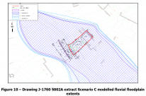
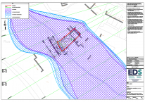
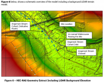
An assessment was made of the Angarrack Stream culvert capacity based on its dimensions and gradient when considering likely inlet and outlet levels from LiDAR data. The capacity was determined to be approximately 9m3/s. When considering larger order fluvial events, particularly those above the 1 in 100 year storm for the Angarrack Stream, the culvert capacity is likely to be overwhelmed. The peak flows detailed in Table 1 indicate the Angarrack Stream flows, calculated using the FEH catchment descriptors method, and give a peak flow of 11.29m3/s. This flow rate is approximately 25% higher than the capacity of the culvert. This will result in accumulation of flows at the culvert inlet headwall and overland flows towards the north and past the subject site. As such, a number of scenarios were considered in the modelling taking into account possible high flows or the culvert blocking.
Selected extracts
Rear of the existing garage location, where the ground level is lowest at 15.45m AOD
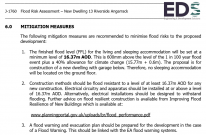
The finished flood level (FFL) for the living and sleeping accommodation will be set at a minimum level of 16.37m AOD. This is 600mm above the level of the 1 in 100 year flood event plus a 40% allowance for climate change (15.77m + 0.6m).
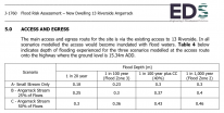
The access/egress route for the proposed development is off Riverside, the highway passing the front of the site. This is inundated with flood waters during all events modelled. The flood depths range from 0.18 to 0.46m with flow velocities no grater than 1.51m/s. These conditions result in ‘Danger for Most’ according to the DEFRA document FD2320/TR2 “Flood Risk Assessment Guidance for New Development”.
The nearest access to higher ground from the site is via a Public Footpath located approximately 55m to the north west along Riverside towards the Railway viaduct. It is recommended residents of the proposed development should evacuate at the earliest signs of a possible flood event occurring and well in advance of any flood taking place if safe to do so using the route demonstrated in Figure 11. If it is not safe to evacuate the property, as the living area is proposed to be located on the 1st floor, residents could safely remain on site during periods of flooding at the site during the flood events considered within this report.
An assessment was made of the Angarrack Stream culvert capacity based on its dimensions
and gradient when considering likely inlet and outlet levels from LiDAR data. The capacity was
determined to be approximately 9m3/s. When considering larger order fluvial events, particularly
those above the 1 in 100 year storm for the Angarrack Stream, the culvert capacity is likely to
be overwhelmed. The peak flows detailed in Table 1 indicate the Angarrack Stream flows,
calculated using the FEH catchment descriptors method, and give a peak flow of 11.29m3/s.
This flow rate is approximately 25% higher than the capacity of the culvert. This will result in
accumulation of flows at the culvert inlet headwall and overland flows towards the north and
past the subject site. As such, a number of scenarios were considered in the modelling taking
into account possible high flows or the culvert blocking.
https://planning.cornwall.gov.uk/online-applications/files/CF26844A40975...
- Printer-friendly version
- Login or register to post comments
- Permalink
Contributions
- Angarrack Defibrillator Team (25)
- Angarrack Inn (336)
- Angarrack Methodist Chapel (3)
- Carol (15)
- Gail (1)
- GordonG (12)
- Hayle Development Group on Facebook (5)
- Hayle Harbour Authority (4)
- Hayle Town Council (5)
- louise (1)
- Lynne (94)
- Mal (1)
- Neil (22)
- Neils Garden Care (9)
- Russell (21)
- Secretary - Christmas Lights (118)
- Steve (3)
- webmaster (5022)
Book page
Similar
Similar across site
- 210805 | Flooding report Riverside - EDS 2021 | Updated | via PA21/02265
- PA21/02265 | Outline planning permission all matters reserved: Construction Dwelling House | Land North West Of 13 Riverside
- PA20/04787 | Proposed construction of 2 storey dwelling | Angarrack Farm House 12 Grist Lane Angarrack Hayle TR27 5HZ
- A Brief History of Flooding in Hayle
- Chronology: SW - Angarrack



Recent comments
2 days 3 hours ago
35 weeks 6 days ago
37 weeks 4 days ago
37 weeks 4 days ago
47 weeks 2 days ago
1 year 7 weeks ago
1 year 32 weeks ago
1 year 42 weeks ago
2 years 2 weeks ago
3 years 27 weeks ago