
Articles
140120 | Flood Relief | PA14/00532 | Hayle Shopping Park And Marsh Lane Nature Reserve Marsh Lane
Submitted by Angarrack.info ... on Tue, 28/01/2014 - 16:49.

Extracts from Appendices Chapter 8 Appendix 8.1 Part 1 Of 5 read more »
140109 | 436 STANDING AGENDA ITEMS a) Hayle Harbour Update
Submitted by Angarrack.info ... on Thu, 09/01/2014 - 01:00.
Via http://www.hayletowncouncil.net/documents/9January2014HTCMinutes.pdf
436     STANDING AGENDA ITEMS
        a)  Hayle Harbour Update

Councillor Bennett reported that he had attended a meeting with the Harbourmaster and
others regarding a proposal for a ‘harbour taxi’ from North Quay, Hayle to St Ives and
possibly to Lelant Quay too. It had been considered that the harbour taxi would be a fun
activity for local people who might want a boat ride over and a walk/bus ride back to Hayle.
read more »131212 | Environment Agency issue new Flooding from Rivers and Sea
Submitted by Angarrack.info ... on Tue, 31/12/2013 - 01:00.

Via http://watermaps.environment-agency.gov.uk/wiyby/wiyby.aspx?lang=_e&topi...
Risk of Flooding from Rivers and Sea
River flooding happens when a river cannot cope with the amount of water draining into it from the surrounding land. Sea flooding happens when there are high tides and stormy conditions.
The shading on the map shows the risk of flooding from rivers and the sea in this particular area. read more »
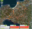
131212 | Environment Agency issue new Surface Water risk flood maps
Submitted by Angarrack.info ... on Thu, 12/12/2013 - 22:08.

Via http://watermaps.environment-agency.gov.uk/wiyby/wiyby.aspx?lang=_e&topi...
Risk of Flooding from Surface Water
Surface water flooding happens when rainwater does not drain away through the normal drainage systems or soak into the ground, but lies on or flows over the ground instead. read more »
August 2013 | Flood Alerts | West Cornwall Rivers
Submitted by Angarrack.info ... on Mon, 05/08/2013 - 11:39.
Flood warnings on West Cornwall Rivers Monday 5th August 2013 via http://www.shoothill.com/FloodMap/ read more »
July 2013 - Angarrack/Loggan Mills Leat Bank Repairs
Submitted by Angarrack.info ... on Tue, 23/07/2013 - 18:22.

Via The Cornishman Thursday 18th July 2013 read more »
Environment Agency Briefing for Angarrack
Submitted by Angarrack.info ... on Fri, 12/07/2013 - 22:56.
The Environment Agency has created a special flooding briefing specifically for Angarrack. A PDF version ideal for printing out is attached below (or click here ) but here are the key points read more »
Flooding information - in and Around Angarrack
Parts of the village are vulnerable to flooding.
Cornwall Council flood information pages
The Environment Agency provides the Floodline Service.
Phone Floodline to find out if you can register for Floodline Warnings Direct. The free service provides flood warnings direct to you by telephone, mobile, fax or pager. You'll also get practical advice on preparing for a flood, and what to do if one happens. read more »
110118 | Flooding in Angarrack
Submitted by Angarrack.info ... on Thu, 20/01/2011 - 15:46.
2011 - Monday 18th January - heavy overnight rain lead to several properties were flooded - and according to the Environment Agency - 25 more were at serious risk read more »
Flooding & Angarrack Stream
Submitted by Angarrack.info ... on Thu, 20/01/2011 - 15:33.
As quoted on Wikipedia
Angarrack is situated in a narrow valley from which the Angarrack River flows before joining the Hayle River at Loggans in a specially constructed culvert which prevents the valley flooding.read more »

